Data & Tools
SCAG has a wide range of data and tools to help you access regional planning data, statistical data and research information.
The SCAG Data Services Program started in the late 1980s with the goal of providing the preeminent source of information for Southern California. The program models an accessible and effective policy for distributing geospatial data and other information. We believe strongly in providing data services to stakeholders that we have incorporated this philosophy into the SCAG Strategic Plan.
Local governments, public agencies, consultants, academics and students use SCAG data services in plans, studies, analyses and presentations. Our services are available to all users at no cost.
Accuracy of the data is a primary concern for SCAG’s data services. SCAG also organizes and maintains datasets to help users efficiently interested parties to efficiently access and apply the data.
scAG DATA SERVICES goals:
- Provide better access to data
- Partner with local governments and public agencies on data standardization
- Enable more diversified users of local government data
- Provide local governments and SCAG with cost savings through data sharing and, when feasible, consortiums
- Lead the adoption of data maintenance, data updates and metadata documentation as part of the normal data distribution process
The SCAG GIS Services Program started in the late 1980s to create the preeminent source of information for the Southern California region. The purpose of the program is to derive and promote a model policy for distributing geospatial data and other information developed and maintained at SCAG.
program goals
- Make geographic information and data more accessible.
- Partner with local governments and public agencies on data standardization.
- Generate opportunities for local governments to find more and diversified users for their data.
- Create cost savings for local governments by sharing data and establishing consortiums when feasible.
- Make maintenance, updates and metadata documentation an accepted part of the data distribution process.
Through the GIS Services Program, SCAG offers specialized software training and data assistance to its member jurisdictions. The GIS Services Program promotes data sharing and updating to enhance region-wide GIS data standardization and helps SCAG maintain effective working relationships with its member cities and key stakeholder agencies. Services include training, data conversion, simple application development and more. These resources help local agencies leverage their assets better to become more efficient, save money, and/or provide new services to their residents and businesses. SCAG’s conservative estimate of savings to local participating jurisdictions is $2 million.
The SCAG GIS Services Program is available to government agencies and private businesses free of cost to inform plans, studies, analyses and presentations. The SCAG GIS Services Program is supported by skilled researchers, statisticians, demographers, economists and GIS technicians with a long history in the industry. Since 2010, the GIS Services Program has provided data support, day-to-day GIS problem-solving and GIS training for 79 local jurisdictions and two partner agencies.
SCAG is implementing an enterprise GIS to develop and disseminate information to interested parties. We are completing our digital geographic databases and are focused on data distribution and standardization.
- Resources
ESRI is the world’s leading provider of GIS technologies. Their main site allows users to become acquainted with the benefits and capabilities of GIS.
ESRI Software Training is available for all levels of GIS (introductory, intermediate, advanced), oftentimes for free.
ESRI’s ArcGIS Online allows users to build and deploy simple web-based mapping applications at no cost.
Urban and Regional Information Systems Association, an association for GIS professionals, offers GIS trainings and certifications.
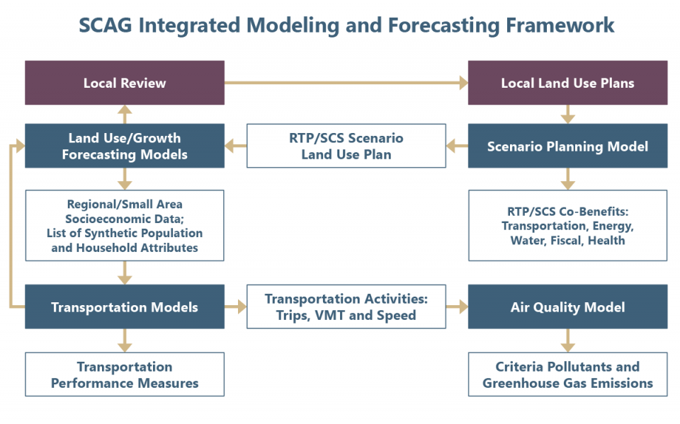
SCAG utilizes an integrated analytical framework to develop growth projections, travel forecasts, and emissions estimates to support the region’s various planning programs.
The primary functions of SCAG’s Modeling and Forecasting Department include:
- Working collaboratively with local jurisdictions to develop socioeconomic growth forecasts as required for regional and local planning.
- Providing modeling services for the development and implementation of SCAG’s plans, programs, and projects.
- Developing and maintaining SCAG’s various analytical tools and data to more effectively forecast travel demand and estimate resulting air quality.
- Providing member services through a robust subregional modeling and data distribution program.
- Promoting state-of-the-art modeling practices.
- Coordinating modeling activities within the SCAG region.
In addition, SCAG also maintains a robust subregional modeling and data service program essential to analyze many of the region’s projects and programs.
SCAG develops and applies state-of-the-art models to support SCAG’s planning programs. These models include:
- Activity-Based Model
- Air Quality Model
- Growth Forecast and Allocation Models
- Heavy-Duty Truck Model
- Land Use Model
- Scenario Planning Model

Member Services
SCAG maintains an active model and data distribution function for member agencies and other stakeholders. SCAG provides modeling data to support stakeholders’ planning programs and to assist in the development and maintenance of city and subregional models. SCAG provides modeling data services to member agencies, universities, and other public agencies by providing model setups, model input data, and model results.
SCAG’s model and data distribution program promotes model consistency, encourages sharing of model data between agencies, and greatly reduces costs for participating agencies. The use of models and data provided by SCAG helps ensure that local planning assumptions and modeling activities are consistent with SCAG’s models and growth assumptions. When local plans are consistent with SCAG’s plans, it guarantees that local planning input can feed seamlessly into the regional planning process. SCAG provides requestors off-the-shelf information or assistance in processing and extracting data. In addition, for subregional model development and large regional initiatives, SCAG provides model setups and documentation required for the requestor to set up and conduct modeling analysis.
To request modeling or forecasting data, complete the following:
For questions concerning modeling or forecasting data requests or to return the completed Data Request Form, please contact Cheryl Leising at (213) 236-1926 or email Leising@scag.ca.gov.
- Connect SoCal 2024
- Highway Performance Monitoring System
- Federal Transportation Performance Management Program
- SB 743 Local Implementation Assistance
Connect SoCal 2024
As a performance-based plan, the investments identified in the Connect SoCal 2024 Regional Transportation Plan/Sustainable Communities Strategy are expected to result in significant benefits to the region, not only with respect to transportation and mobility, but also air quality, economic activity, job creation, sustainability, public health and equity.
- Chapter 5: Measuring Our Progress
Chapter 5 of Connect SoCal 2024 describes the performance measures projected from the implementation of Connect SoCal 2024. Chapter 5 also describes how Connect SoCal 2024 addresses statutory requirements regarding environmental justice, Senate Bill 375, greenhouse gas emission reductions, transportation conformity and the federal Transportation Performance Management program.
- Performance Monitoring Technical Report
The Connect SoCal 2024 “Performance Monitoring Technical Report” expands the performance results presented in Chapter 5, providing a quantitative mechanism to link the regional goals identified in Connect SoCal 2024 with implementation performance to meet regional goals.
- Caltrans Transportation Planning Resources
The Caltrans Transportation Planning website provides a variety of resources related to performance monitoring, including the 2050 California Transportation Plan
Highway Performance Monitoring System
The Highway Performance Monitoring System (HPMS) program plays an important role in providing Caltrans and the Federal Highway Administration with consistent data to analyze the performance of the National Highway System, in guiding federal highway funding programs and facilitating SCAG’s ability to accurately assess regional performance relative to vehicles miles traveled (VMT), traffic congestion and transportation system operational efficiency. Each spring, SCAG coordinates with Caltrans and local jurisdictions to solicit updated HPMS traffic data.
Caltrans produces annual statewide HPMS data reports, available for download on the Caltrans website. The Caltrans HPMS reports are currently available for the years 2001 through 2022.
Federal Transportation Performance Management Program
In 2012, the federal transportation authorization legislation, known as MAP-21, established a national performance-based transportation monitoring and reporting system, including specific performance measures to assess progress toward national transportation goals relative to traffic safety, infrastructure condition, highway operational efficiency and transit system performance. The federal commitment to performance-based transportation system planning and programming continued through subsequent legislative packages, including the FAST Act in 2015 and the Infrastructure Investment and Jobs Act in 2021.
As the metropolitan planning organization for the six-county Southern California region, SCAG is required to develop a Federal System Performance Report to include with each update of the Regional Transportation Plan. The System Performance Report describes the federally designated transportation performance measures, the statewide and regional targets associated with each of the measures and the progress being made toward targets. The Connect SoCal 2024 “Federal System Performance Report” is included as a section of the “Performance Monitoring Technical Report.”
SB 743 Local Implementation Assistance
To promote the successful local implementation of Senate Bill (SB) 743, SCAG sought opportunities to coordinate with various local jurisdictions throughout the region to provide technical and policy assistance in the development of local and county-wide SB 743 implementation tools and strategies.
- SB 743 Local Implementation Assistance Final Reports
- Los Angeles Department of Transportation Vehicle Miles Traveled Mitigation Program
The Local Profiles reports provide jurisdictions with updated data and analysis to support community planning and outreach efforts. They are also useful resources for the business community, academia, and residents of Southern California. The most recent Local Profiles reports (2019) are available for download below.
While the Local Profiles were not produced for 2021, the 2021 Local Profiles dataset is available and may be accessed here.
Contact
For additional information, please contact:
Mike Gainor
Senior Regional Planner
(213) 236-1822
gainor@scag.ca.gov
Demographic profile summary reports for each of the 197 cities in the SCAG region and the unincorporated areas in each of the six counties based on data provided through the SCAG SoCal Atlas tool. The most recent SoCal Atlas Jurisdictional reports are available for download below.
Contact
For additional information, please contact:
Mike Gainor
Senior Regional Planner
(213) 236-1822
gainor@scag.ca.gov
The SCAG Data Services Program started in the late 1980s with the goal of providing the preeminent source of information for Southern California. The program models an accessible and effective policy for distributing geospatial data and other information. We believe strongly in providing data services to stakeholders that we have incorporated this philosophy into the SCAG Strategic Plan.
The SCAG GIS Services Program started in the late 1980s to create the preeminent source of information for the Southern California region. The purpose of the program is to derive and promote a model policy for distributing geospatial data and other information developed and maintained at SCAG.
program goals
- Make geographic information and data more accessible.
- Partner with local governments and public agencies on data standardization.

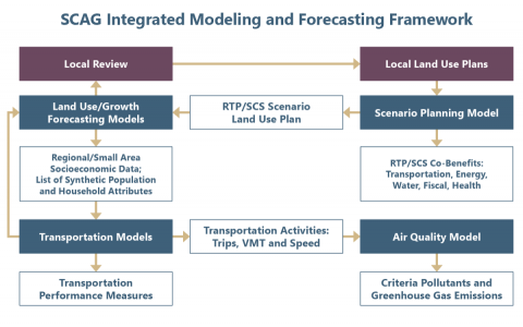
SCAG utilizes an integrated analytical framework to develop growth projections, travel forecasts, and emissions estimates to support the region’s various planning programs.
The primary functions of SCAG’s Modeling and Forecasting Department include:
Connect SoCal 2024
As a performance-based plan, the investments identified in the Connect SoCal 2024 Regional Transportation Plan/Sustainable Communities Strategy are expected to result in significant benefits to the region, not only with respect to transportation and mobility, but also air quality, economic activity, job creation, sustainability, public health and equity.
The Local Profiles reports provide jurisdictions with updated data and analysis to support community planning and outreach efforts. They are also useful resources for the business community, academia, and residents of Southern California. The most recent Local Profiles reports (2019) are available for download below.
While the Local Profiles were not produced for 2021, the 2021 Local Profiles dataset is available and may be accessed here.
Contact
For additional information, please contact:
Mike Gainor
Senior Regional Planner
(213) 236-1822
gainor@scag.ca.gov
Demographic profile summary reports for each of the 197 cities in the SCAG region and the unincorporated areas in each of the six counties based on data provided through the SCAG SoCal Atlas tool. The most recent SoCal Atlas Jurisdictional reports are available for download below.
Contact
For additional information, please contact:
Mike Gainor
Senior Regional Planner
(213) 236-1822
gainor@scag.ca.gov
